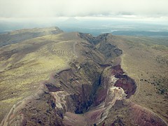
Mt. Tarawera is one of the volcanoes in the Okataina zone where eruptions have been occurring over the past 20,000 years. Tarawera's most recent eruption was in 1886 when it split along a fault creating this 8 km rift. The rift spread south of this image into lake Rotomohana causing a massive explosions, killing over 100 people and destroying the then popular tourist destination the Pink and White Terraces. An extensive description of the Okataina Volcanic Centre can be found under the Okataina heading at the NZ GNS volcanoes site.
Some idea of scale can be gained from the walking tracks along the edges of the rift (access to the mountain is by organised tour only).
Visible in the background is the cone of Mt Edgecumbe another Okataina volcano which last erupted 3200 years ago.
This image was taken from a Volcanic Air Safaris float-plane. I've had to adjust the colour levels and curves to compensate for overexposure, haze, the overcast conditions, and the tint of the windshield.
img_7378-levels-curves-usm4.jpg
Saturday, November 11, 2006
Saturday, October 14, 2006
There and back again in one day.
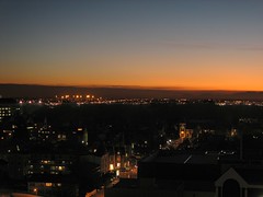
Back in the Hotel room where we started from in the morning. Looking back toward the mountains. Here is the hotel on maps.google.com.
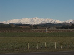
Sheep
A collection of New Zealand travel photos wouldn't be complete without some sheep - here's the best I could do.
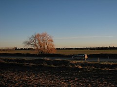
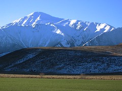
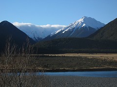
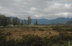
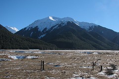
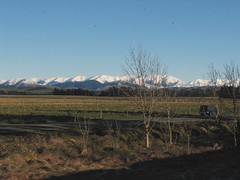
Revisiting the Canterbury Plains
The evening sun created some nice lighting effects. The evening contrast between the fields, tussock and the mountains was nicely caught by my partner (using a Canon A80).
The train was now moving a full speed across the plain - the combination of low light and rapidly changing views made photography a bit difficult.
The train was now moving a full speed across the plain - the combination of low light and rapidly changing views made photography a bit difficult.
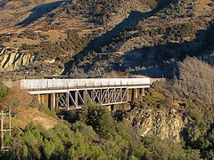
Viaduct (Broken River area?)
Evening sun on tussock
My partner took this image with a Canon A80. The image was taken at around 16:30 in the afternoon. The sun angle at this time of day is quite low - winter is only just leaving us and we are also quite far south.
Sunday, October 08, 2006
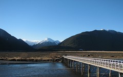
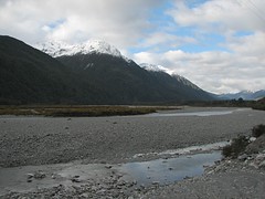
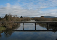
Bridge on Riversdale Road?
Matching the view, terrain, bridge and road to yahoo maps and other maps of the region makes me suspect this is the bridge on Riversdale road at this point on the map. The snow covered mountains are a zoomed out view of the ones in the previous image.
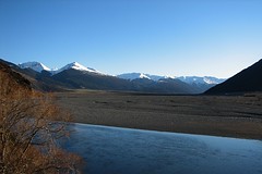
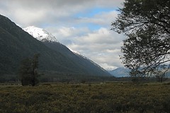
Distant clouds
As with the next image, I think this image was taken where the road and rail come back together at this point on the Waimakariri. The sun is starting to get quite low in the west.
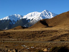
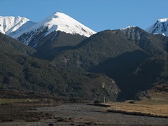
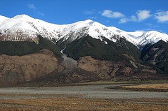
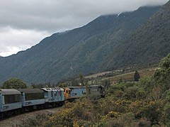
Highway 73
This image was taken in the wide valley the contains the shingle beds of Waimakariri River in the Bealey Spur area. The road (just visible) runs on one side of the valley and the railway on the other. I think this may be a different angle and zoom onto the left of the area covered by the "Layer Cake" image posted previously.
The lower part of the image has been tweaked to bring out the colours in the scrubby lower slopes (I lowered the overall brightness and contrast in this area only).
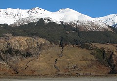
The lower part of the image has been tweaked to bring out the colours in the scrubby lower slopes (I lowered the overall brightness and contrast in this area only).
Bridge
I think the tiny bridge visible in the bottom of the picture is one of the bridges on State Highway 73 near Bealey Spur. This image was probably taken close to the location of the previous one.
Thursday, October 05, 2006
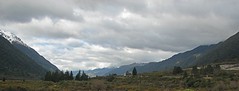
Layer Cake
Somewhere between Arthurs Pass and Bealey Spur. Possibly at the location indicated on the yahoo map link. I placed the map link approximately on the rail line - you can see features that might match if you south of the marked position.
GAS MASK AND MONITOR MUST BE CARRIED
The Otira Tunnel is not a place to linger without a supply of good air. I wrote more about the tunnel here.
Monday, September 25, 2006
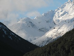
Climbing toward Otira 2
The sunlight shone into the middle of this valley - if viewed large, you can see that the sunlight catches some power poles on the valley floor.

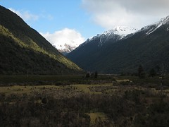
Climbing toward Otira
As we climbed toward the Otira side of Arthurs pass a little more sunlight started to be evident. It seemed likely that the other side of the alps would have clear skies.
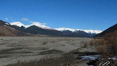
Shingle banks
I'm a bit lost as to the exact location of the images in this area - neither google maps or yahoo maps has sufficient resolution in this area.
Climbing toward Otira 1
Light was a bit scarce at this point - I could have really benefited from a image sensor that copes better with poor light.
West Coast vista
This would have been a great place to take a panorama, but the train wasn't going to stand still - a wide crop is the best I could do.
The TranzAlpine
There were quite a few oportunities to catch the train turning a corner - but I lucked out on getting a nice clear shot. I had to post process this image a fair bit - it was underexposed and noisy.
Sunday, September 24, 2006
West Coast in a moody light.
The cloud was still shrouding the West Coast for the return leg of the journey.
Bank of New Zealand Building
Former Bank of New Zealand building in Greymouth. We spent most of the short stopover in Greymouth geting a nice bite to eat at the The Smelting House Cafe on MacKay St.
The bank is located here (the railway station is at the east edge of the google map view).
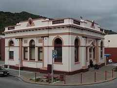
The bank is located here (the railway station is at the east edge of the google map view).
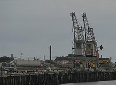
The Port of Greymouth
These two aged Greymouth cranes are the most prominent feature of the waterfront - they can be clearly seen here on google maps. I never got close to them - google maps shows coal piled up behind them (the West Coast produces large amounts of coal).
This image was taken from the river bank near the old BNZ building in the next image.
This image was taken from the river bank near the old BNZ building in the next image.
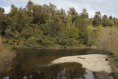
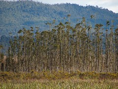
West Coast Forest
The train travelled parallel to a river somewhere between Moana and Greymouth. The opposite bank was well forested but rather hard to photograph because trees and scrub on the near side kept blocking the view.
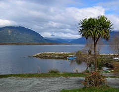
Lake Brunner / Lake Moana
View from the station at Lake Brunner (Lake Moana). Located here on google earth. Native "Cabbage" Tree in foreground.
My partner took this with a Canon A-80
My partner took this with a Canon A-80
Wednesday, September 06, 2006
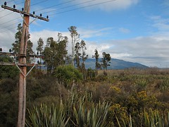
Rugged West Coast Scrub
Here we have a typical sampling of West Coast scrub land. Flax in the foreground. The flax-like bush standing up is the native "Cabbage Tree" (Ti Kouki). And of course, the yellow flowered shrubs are yet more introduced gorse.
As I described in my previous post, by looking at landmarks and buildings in surrounding images,I'd say this image was taken near the middle of this google maps view somewhere between Te Kinga and Ruru, just before Moana Station (the track runs along side Lake Brunner Road).
Gorse was introducted to New Zealand by European settlers. In New Zealand, gorse has no natural pests or diseases. Once the native bush and forests were burnt and cleared, gorse spread EVERYWHERE. We've personally spent many weekends with gloves, loppers, pruning saws, and Roundup (Glyphosate) keeping it under control (we are talking dump truck sized quantities from a domestic section - it really does get around). If kept under control, gorse is OK protection for regenerating native bush - so it's not all bad.
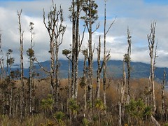
Tall and Scrappy
Stands of tall weathered trees are quite common. I guess it's the wild West Coast weather. The yellow flowers in the foreground are the flowers of the prickly gorse shrub. In front of the gorse we have native flax.
By looking at landmarks and buildings in surrounding images,I'd say this image was taken near the middle of this google maps view somewhere between Te Kinga and Ruru, just before Moana Station (the track runs along side Lake Brunner Road).
By looking at landmarks and buildings in surrounding images,I'd say this image was taken near the middle of this google maps view somewhere between Te Kinga and Ruru, just before Moana Station (the track runs along side Lake Brunner Road).
Tuesday, September 05, 2006
Te Kinga
This is most likely the Cashmere Bay Road bridge at Te Kinga (google earth hires) encountered just prior to Lake Moana (AKA Lake Brunner).
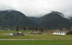
Farm near the Lake Brunner Road
By matching the hills in the background and the time the image was taken I suspect this image was taken near here on the google map view.
After exiting the Otira tunnel we were now on the rugged West Coast side of the Southern Alps. The transition to the West Coast was marked by the transition from clear to overcast skies. The weather for the trip was fine on both sides of the Alps. This is often not case because the Alps tend to bottle up bad weather on one side or the other. Our trip was booked a few days ahead after consulting the NZ Met Service's forcast for the week ahead.
This image was taken almost an hour after the previous one - I'm missing images for quite a chunk of the area from Otira to Lake Brunner. When covering the return journey, I'll post images of the area I missed on this outward leg.
I'm now using the new Flickr yahoo maps features, but the yahoo satellite images aren't as detailed as googles (just click on any image and when at yahoo click on the map links listed under each image).
Monday, August 28, 2006
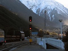
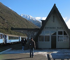
Last stop this side of the Southern Alps
Arthurs Pass Railway Station. Arthurs Pass is named after Sir Arthur Dudley Dobson and is now contained within the Arthurs Pass National Park. After the Arthurs Pass Station, the train enters the 8500 metre Otira Tunnel descending 250 metres over the length of the tunnel (the area traversed can bee seen on here on map.google.com). After the train enters the tunnel, a large door closes over the entrance and large fans begin extracting the exhaust gasses. The viewing carriage is off limits until we reach breathable air on the other side.
I should have tried fill-in-flash here. In haste I used ISO200 - which was far too noisy, but Noise Ninja has fixed some of this.
I should have tried fill-in-flash here. In haste I used ISO200 - which was far too noisy, but Noise Ninja has fixed some of this.
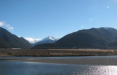
The works: tussock, shingle, rock, trees, snow
Here are all the elements of upper Waimakariri scenery in one image.
This was taken by my partner using a Canon A80 - underexposed to keep the snow detail - I used Noise Ninja to reduce the noise in the sky. Boosted the saturation a tiny bit. Rotated a bit (the moving train makes keeping things level a bit tricky).
This was taken by my partner using a Canon A80 - underexposed to keep the snow detail - I used Noise Ninja to reduce the noise in the sky. Boosted the saturation a tiny bit. Rotated a bit (the moving train makes keeping things level a bit tricky).
Tussock land
As well as shingle, there's quite a bit of flat tussock land. Gives the impression of being a hard life for a plant.
Because we did the trip in late winter, the sun angle is still quite low. As a result, lens flair is a bit of an issue - a lens hood would have been a good idea. I used a Lensmate Adaptor so I could fit a UV filter to protects the camera lens and zoom-mechanism from dust etc. A UV filter is probably a good idea if you're going to spend a lot of time in the open air viewing carriage. In this case the UV filter may be increasing the likely hood of visible flair.
Because we did the trip in late winter, the sun angle is still quite low. As a result, lens flair is a bit of an issue - a lens hood would have been a good idea. I used a Lensmate Adaptor so I could fit a UV filter to protects the camera lens and zoom-mechanism from dust etc. A UV filter is probably a good idea if you're going to spend a lot of time in the open air viewing carriage. In this case the UV filter may be increasing the likely hood of visible flair.
The vast shingle beds of the Waimakariri
Headed toward Aurthers Pass. Still with the Waimakariri in this region: maps.google.com
This image was underexposed at ISO100 to try and retain detail in the snow - as a result it was a bit noisy - so I processed it with Noise Ninja, then adjusted the levels and saturation in The Gimp. Original settings:
This image was underexposed at ISO100 to try and retain detail in the snow - as a result it was a bit noisy - so I processed it with Noise Ninja, then adjusted the levels and saturation in The Gimp. Original settings:
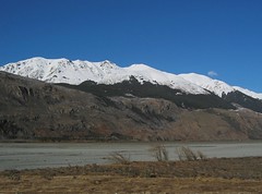
Upper reaches of the Waimakariri
At this point the river is braided with wide shingle beds, snow capped hills rise around it (maps.google.com).
img_6497-1024x768-usm2
img_6497-1024x768-usm2
Viaduct after crossing it.
One of the first viaducts. The viaducts have high railings that defeat any attempt to use them to get good photos - make the most of the approaches.
Could possibly be this one: maps.google.com. But there is a low resolution region south of this location that may also contain viaducts.
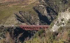
Could possibly be this one: maps.google.com. But there is a low resolution region south of this location that may also contain viaducts.
Waimakariri Gorge
Waimakariri River and Waimakariri Gorge. Lots of tunnels and viaducts around here. The tunnels can make photography a bit frustrating - shoot on high speed at any opportunity.
Satellite view of the approximate location: maps.google.com
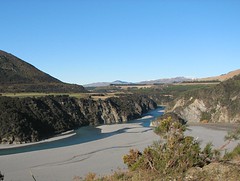
Satellite view of the approximate location: maps.google.com
Exposed to the elements.
Here is a shot of me on the TranzAlpine viewing platform. This is the kind of garb that kept me reasonably warm while the train zipped along at the end of our winter. Under the light breathable coat I wore a polar-fleece jacket, polar-fleece top, and a thermal t-shirt. Note fingerless gloves and warm hat. A scarf to fend off Diesel soot and other dust would have also been a good idea. The airconditioned carriages can be quite warm, so a layered approach is probably the best way to go.
This shot was taken by my partner with a Canon A80 (my shots were taken with an S2 IS).
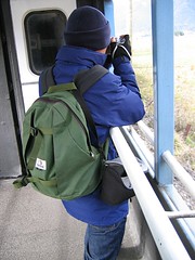
This shot was taken by my partner with a Canon A80 (my shots were taken with an S2 IS).
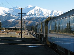
Springfield
The TranzAlpine standing at the platform at Spingfield - where everyone was allowed to jump off and stretch their legs or take snaps. I managed to get this picture clear of any other tourists. Trainspotters - note the loco number is visible. Also note the large windows on the carriages.
The road and rail depart company for a while around here. This can be clearly seen here on the maps.google.com satellite view of the area.
I've replaced the original image with one where a contrast-mask has been applied to the train only and an unsharp mask has been applied to the non-train only. This brings out the train a little more (tool used was The Gimp).
img_6459-cm-g-1-1024x768-usm2
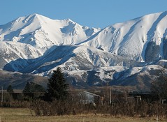
Zooming in on the Southern Alps
This image used about half the zoom range at an optimal aperture at quite a slow shutter speed - I think I was gaining some confidence at this point and decided to risk some slower shots.
Horticulture on the Canterbury Planes
Another image while headed toward Springfield along side highway 73. The train was moving quite fast at this point - so I kept the shutter speed high.
We were somewhere in flat of the Cantebury Plains - zoom in on this maps.google.com to see the track (no idea where we were exactly).
img_6454-bc-1024x758-usm2
We were somewhere in flat of the Cantebury Plains - zoom in on this maps.google.com to see the track (no idea where we were exactly).
img_6454-bc-1024x758-usm2
TranzAlpine - along side highway 73
From the open air viewing carriage of the TranzAlpine. I've never before shot from a moving train while standing - so it was pleasing to find that many images turned out just fine. This part of the journey tracks state highway 73.
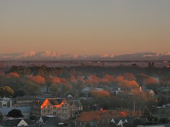
Christchurch - looking toward the Southern Alps
Looking west from floor 13 of the Rydges Hotel on Oxford Street toward the tree lined banks of the Avon and the trees of the Hagley Park and the Botanic Gardens, and in the far west, New Zealand's Southern Alps. This is the morning that greeted me for my journey on the TranzAlpine express to Greymouth on the West Coast. Here is the hotel on maps.google.com (scroll west some blocks to see the park and gardens).
This image was quite underexposed. I used Gimp to post process it with a neutral density filter and to bring back the colours. I then used NoiseNinja to remove much of the noise. Gimp was then used to resize it to 1024x768 with a little unsharp mask to restore the detail lost from the resize.
This image was quite underexposed. I used Gimp to post process it with a neutral density filter and to bring back the colours. I then used NoiseNinja to remove much of the noise. Gimp was then used to resize it to 1024x768 with a little unsharp mask to restore the detail lost from the resize.
Subscribe to:
Comments (Atom)