Digital Trails

Hiking in New Zealand in comfort.

Tuesday, September 05, 2006

Te Kinga


Te Kinga
Originally uploaded by mchnz.
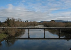
This is most likely the Cashmere Bay Road bridge at Te Kinga (google earth hires) encountered just prior to Lake Moana (AKA Lake Brunner).
Posted by Digital Trails at 10:24 am
Email ThisBlogThis!Share to XShare to FacebookShare to Pinterest

No comments:

Post a Comment

Newer Post Older Post Home
Subscribe to: Post Comments (Atom)

Search This Blog

About Me

digitaltrails
View my complete profile

Links

  • New Zealand Topo Maps
  • NZ Forecasts
  • NZ Mountain/Parks Forecast

Blog Archive

  • ►  2007 (34)
    • ►  May (1)
    • ►  April (31)
    • ►  March (2)
  • ▼  2006 (45)
    • ►  November (1)
    • ►  October (14)
    • ▼  September (16)
      • Climbing toward Otira 2
      • Climbing toward Otira
      • Shingle banks
      • Climbing toward Otira 1
      • West Coast vista
      • The TranzAlpine
      • West Coast in a moody light.
      • Bank of New Zealand Building
      • The Port of Greymouth
      • West Coast Forest
      • Lake Brunner / Lake Moana
      • It's a hard life
      • Rugged West Coast Scrub
      • Tall and Scrappy
      • Te Kinga
      • Farm near the Lake Brunner Road
    • ►  August (14)
Travel theme. Powered by Blogger.