Central Crater, Tongariro, Ngauruhoe. The floor of "Central Crater", in the foreground, is actually a weathered ash and lava filled old drainage basin rather than a true crater. Note the poles marking the track from Red Crater - if the weather turns bad never lose sight of the track (and carry a compass and map and know how to use them).
More images at http://www.flickr.com/photos/digitaltrails
Saturday, May 12, 2007

Sunday, April 22, 2007
The end - almost
Due to the need to keep to schedule to meet the boat, the more frequent encounters with walkers and bike riders coming the other way on day outings, and the vast expanse of the beech forest, we somehow both failed to take a good snap of the final walk through the forest - perhaps next time.
After reaching the end of the track there was additional 800m walk to the jetty to meet the boat that would take us back to Picton.
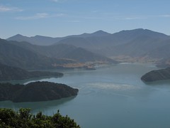
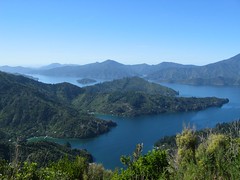
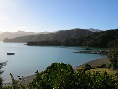
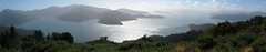
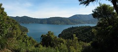
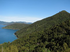
Looking back on Mistletoe Bay
Looking back on Mistletoe Bay. The track runs down the largest hill in the centre of the image down across the saddle visible on the extreme left of the image. The James Vogel walk comes down from the main track through the most darkly shaded trees in the centre of the image. Shortly after this image the remainder of the track passes though a long stretch of beech forest.
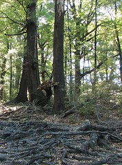
James Vogel Walk to Mistletoe Bay
On this final leg you have the option of walking the James Vogel nature track. The track winds through beautiful lush forest. The track leads down into Mistletoe Bay where there is a well equipped camping ground. The track is a bit rough - with lots of tree roots - as can be seen here.
Wasps seem to hang around the black barked beech trees, but we found that providing you take care, they don't bother you much.
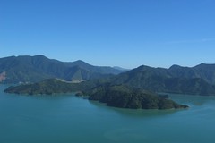
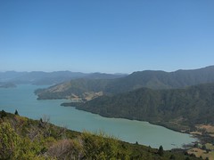
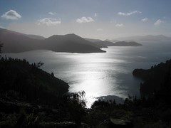
Hilltop lookout zoom of Waitaria Bay
A zoomed view taken shortly after begining our descent from the lookout, the grassland is in Waitaria Bay. Weka Point and Kaiaho Point are in the foreground. About 45 minutes after you start the descent from the lookout side-track, you have the additional option of walking the James Vogel nature track - in our opinion, this is also not to be missed.
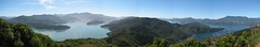
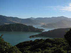
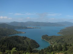
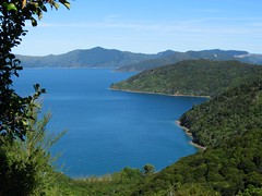
Hilltop lookout - two Sounds
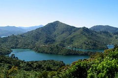
The hilltop lookout provides views of Kenepuru Sound (left) and Queen Charlotte Sound (right). The Queen Charlotte track follows the ridge line running down the centre of the image. A voyage into the picture on the Kenepuru side will take you to a dead end at the farmland at the head of the sound, where as sailing into the picture on the Queen Charlotte side will lead you to the open seas of Cook Strait.
Hilltop lookout: Queen Charlotte Sound
The hilltop lookout is one of the optional side trips you can take. It is worth the effort - you'll be rewarded by stunning views of both Kenepuru Sound and Queen Charlotte Sound.
This shot shows Lochmara Bay and Double Cove. Allports Island can be seen in the background.
This shot shows Lochmara Bay and Double Cove. Allports Island can be seen in the background.
Weka Point and Ferndale scenic reserve, Kenepuru Sound
After climbing to 407 metres the track slowly descends throughout the leg to Mistletoe Bay.
Although the upmarket accommodation and pack-transfer services can make the Queen Charlotte track sound like an easy beginners walk, the length of the last two stages and the undulating nature of the ridge line track, fully justify it's rating as moderate rather than easy.
We wore well broken in boots. These, coupled with the excellent "Trampers Wool" padding supplied as part of our "Marlborough Sounds Adventure Company" orientation kit, allowed us to complete the trip without any blisters. A walking stick was also useful for some of the slopes and for taking the pressure off of the odd sore joint at times.
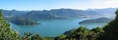
Kenepuru Sound at 407 metre high point
The early morning climb to 407 metres from Portage is rewarded by a great view of Kenepuru Sound. This panorama shows Weka Point, Goulter Bay scenic reserve and Kaiaho Point.
Day 4 - Portage to Anakiwa - Kenepuru Sound (near Portage)
The day started with a steep ascent from sea level to 400 metres. This photo was taken on our way up, and features Portage Bay and "Take in" Bay. Note the slither of land at the back of Take in Bay that prevents Kaiaho Point peninsula from becoming an island.
The saddle between Portage Bay in Kenepuru Sound and Torea Bay in Queen Charlotte sound is a low point in the ridge line where the Maori used to carry canoes between the two sounds to avoid having to navigate around huge peninsula on the other side of Kenepuru sound.
Friday, April 20, 2007
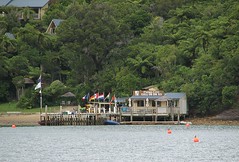
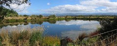
Kenepuru Sound from Portage Resort Hotel
Our accommodation for the night was Portage Resort Hotel in Kenepuru Sound. The hotel used to run the post office and telephone exchange for the area. We asked the hotel's cafe/bar if we could have our dinner to take out so we could enjoy this view from our deck.
Portage is a bit closer to civilisation, cell phones can get a signal, and it's accessible by road (or water taxi). It's a good place to spend some time as there are plenty of activities on offer - many walkers take a days break at Portage.
The local shop was interesting. It will sell you groceries and fuel, and they'll whip up some fish and chips for you if you're hungry.
Progress along Kenepuru Sound
This view looks back across Kenepuru Sound to our starting point for the day. As we climbed out of Punga Cove six hours ago, we saw an area of farmed land that stretched down to Kenepuru Sound - the same farmed land that appears in the previous photo.
This image was taken very near the last Shelter about 6 kilometres prior to reaching Portage (at about 19.5 kilometres from our start this morning).
This image was taken very near the last Shelter about 6 kilometres prior to reaching Portage (at about 19.5 kilometres from our start this morning).
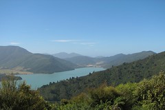
Kenepuru Sound
Day 3 features views of both the Queen Charlotte Sound and Kenepuru Sound. Kenepuru Sound is known for its snapper fishing and mussel farms, as well as its scenery.
The farmland at the right of the image stayed visible as we progressed along the ridge line, providing a useful marker by which to judge progress throughout the day.
The farmland at the right of the image stayed visible as we progressed along the ridge line, providing a useful marker by which to judge progress throughout the day.
Bay of Many Coves
The Bay of Many Coves faces into Queen Charlotte Sound. Beyond the long thin needle of Snake Point, you can see the south western part of Arapawa Island.
There were more people on this section of the track, probably because the second part of the Queen Charlotte track is accessible by road.
One of the things we learnt was that the estimated walking times allow some time for quick photo stops, but if you want to stop for lunch, rest, or spend time composing every photograph, you'll need to allow extra time. We took a steady approach to walking the track, but we noticed other people used different styles such as going for it hard and fast, then resting. We ended up leap-frogging each over the next two days.
Eatwell's Lookout
Eatwell's lookout is an optional side trip. The view on a clear day is definitely worth the 75 metre ascent. This panorama is of Queen Charlotte Sound - Endeavour Inlet dominates the left three quarters of the image. Scott Point and Edgecombe Point mark the entrance of Endeavour Inlet (about 2/3 and 3/4 of the way from the left respectively).
Picnic spot overlooking Deep Bay
Just over an hour into our walk, traveling south east along a ridge above Endeavour Inlet, we came across a picnic table. With a view like this, who could resist stopping for morning tea!
Day 3 - Punga Cove to Portage - View from our chalet
By the next morning, the cloud and strong winds had disappeared, and the day dawned brilliantly fine. The clearance in the weather was fortunate - day 3 of the walk is regarded as the most difficult because the track is undulating, exposed and rocky in parts. It is also the longest walk of the four days. Because this was our first attempt at multi-day walk, we got up early to give ourselves plenty of time to complete this 25 kilometre leg.
Monday, April 16, 2007
Punga Cove Resort
Although day two of our walk covered a relatively short distance (15.6 kilometres), it seemed to take a long time to arrive at our destination. Not knowing exactly where you are makes the journey seem much longer. On rounding a bend we sighted this colourful jetty and by taking this 12x zoom image we were able to confirm that our accommodation for the night was within sight. Note some of the chalets are visible in amongst the punga trees on the left of the image,
As well as an excellent restaurant, beer and pizza can be purchased from the cafe on the jetty.
As well as an excellent restaurant, beer and pizza can be purchased from the cafe on the jetty.
Entering "Big Bay"
Much of this part of the walk was closer to sea level. Several times, the appearance of many punga ferns, such as those in the foreground of this image, gave the false impression that we nearing Punga Cove. But in this case we still had about 7 kilometres to walk around to the other side of Big Bay.
Note that the proper name for these tree ferns is ponga but most Kiwis use the word punga instead. Furthermore, many Kiwis use punga generically for tree ferns of all types, so its not a precise term by any means.

Note that the proper name for these tree ferns is ponga but most Kiwis use the word punga instead. Furthermore, many Kiwis use punga generically for tree ferns of all types, so its not a precise term by any means.
Tractor on the side of the QC track
You can take a side trip to visit old antimony mines at the head of Endeavour Inlet. During the 1880's, about 300 people were employed to mine antimony which was used to harden lead and pewter. We decided not to walk this side trip because it takes about two hours return.
We spotted this tractor just past the start of the antimony mine side trip.
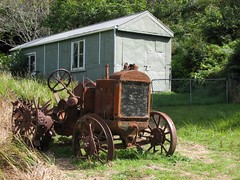
We spotted this tractor just past the start of the antimony mine side trip.
Furneaux Lodge and grounds
This photo shows the main administration building housing the restaurant, bar and office. The lodge is spread across 3 acres of flat land.
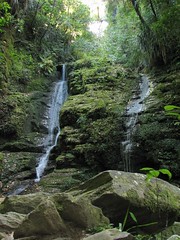
We started day two by walking the Furneaux Lodge waterfall side trip. The walk is worth doing for the bush alone - there are a number of old Rimu trees along the route. One of the highlights of this walk was a sighting of a tomtit - the first time we had ever seen one of these birds in the wild.
Sorry no photos of the waterfall - a dry spell had reduced it to a trickle and it was too dark under the trees for a good shot anyway.
Queen Charlotte Track - Day 2 - View from Furneaux Lodge
We woke refreshed the next morning and soaked up this view of Endeavour Inlet before breakfast.
Part of the charm of Furneaux Lodge is its isolation. It is accessible only by foot or by water taxi. There is no cellphone coverage. The sky is incredibly black at night making it perfect for star gazing.
Part of the charm of Furneaux Lodge is its isolation. It is accessible only by foot or by water taxi. There is no cellphone coverage. The sky is incredibly black at night making it perfect for star gazing.
Saturday, April 14, 2007
Endeavour Inlet panorama
This panorama was snapped near the saddle that crosses over from Resolution Bay to Endeavour Inlet. From the sun angle, it seems we are looking at Endeavor inlet to the west of the camera.
Having reached the 220m saddle into Endeavor Inlet, we were on the last leg of the journey to Furneaux Lodge, our accommodation for the first night. From this point the track begins a slow descent back to sea level - over a distance of 6km.
One of the unusual things about the Queen Charlotte Track is the range of accommodation along the track – everything from camping grounds through to luxury resorts. We chose the latter.
The Marlborough Sounds Adventure Company arranged all the transport, accommodation and luggage transfers for us. Daily packed lunches were provided by each lodge/resort. Cougar Line were responsible for the transportation and transfers. Everything was well organised, and ran to plan.
Resolution Bay - the climb out
Having walked around Resolution Bay at heights as low as 30 metres above sea level, this photo was taken at about 125 metres, as we climbed toward a saddle which passes to the right of the summit visible in the extreme right of this image. Because the Sounds are flooded hills, you seldom walk at sea level and never encounter any beaches on the walk proper.
Resolution Bay
The track is generally well formed and wide. Depending what time of the year you walk the track, you may need to share the track with mountain bikers. Everything is well sign posted so it's difficult to get lost. There are posts every five kilometres that show the distance to Anakiwa, the end of the track.
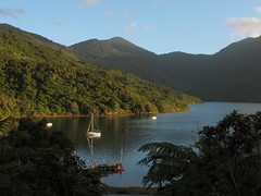
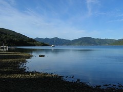
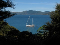
Yacht at anchor in Resolution Bay
This yacht was anchored in Resolution Bay which is south west of Ship Cove: the track climbs the ridge between the two. Because we left Ship Cove later than everyone else, we had the track pretty much to ourselves.
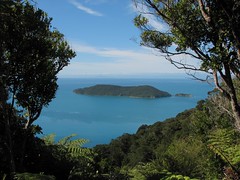
Motuara Island
The Queen Charlotte track climbs steeply out of Ship Cove into virgin forest. This photograph of Motuara Island was taken from a lookout point on the ridge between Ship Cove and Resolution Bay.
(For precise locations - click on the image and then use the Flickr map link.)
(For precise locations - click on the image and then use the Flickr map link.)
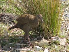
Ship Cove resident Weka
This weka, obviously used to the daily influx of tourists, was loitering around Cook's memorial as we stopped to take photos.
Weka sightings are quite common along the Queen Charlotte track. They have a reputation for stealing gear, so it's best not to feed them.
Weka sightings are quite common along the Queen Charlotte track. They have a reputation for stealing gear, so it's best not to feed them.
Queen Charlotte Track - Day 1 - Ship Cove waterfall
This waterfall can be found a short distance from Ship Cove. Of the group of people dropped off at Ship Cove at the same time as us, we were the only ones who walked this side track.
There are a number of side trips along the Queen Charlotte track. In addition to this track, we walked to Furneaux Lodge waterfall, Eatwell's lookout, the hilltop lookout and we walked the James Vogel nature track. These side trips added another 10 kms to our walk, but all of them were worth the extra effort.
For precise locations - click on the image and then use the Flickr map link.
Tuesday, April 10, 2007
Putangirua Pinnacles - Wairarapa
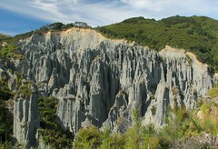
Rain erodes the sand exposing rocks deposited in the gravel beds of an old flood plain that first began to form 10 million year ago.
This photo of the Putangirua pinnacles was taken from the lookout. Most people walk up the stream bed and completely miss this lookout which is part of the bush walk. If you have the time and energy, it's worth viewing the pinnacles from both vantage points.
The Putangirua Pinnacles feature in Peter Jackson's movie version of "The Lord of the Rings: Return of the King", they can be seen at the beginning of trek into the "Paths of the Dead."
More images of the Putangirua Pinnacles are available on my flickr pages - just click on the image to be taken there.
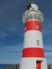
Cape Palliser lighthouse
The Cape Palliser lighthouse was installed in 1897. More Cape Palliser and Wairarapa images can be seen at the flickr pages.
Monday, March 12, 2007
Subscribe to:
Posts (Atom)