Digital Trails

Hiking in New Zealand in comfort.

Monday, August 28, 2006

The vast shingle beds of the Waimakariri


The vast shingle beds of the Waimakariri
Originally uploaded by mchnz.
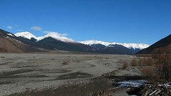
Headed toward Aurthers Pass. Still with the Waimakariri in this region: maps.google.com

This image was underexposed at ISO100 to try and retain detail in the snow - as a result it was a bit noisy - so I processed it with Noise Ninja, then adjusted the levels and saturation in The Gimp. Original settings:
Posted by Digital Trails at 9:26 am
Email ThisBlogThis!Share to XShare to FacebookShare to Pinterest

No comments:

Post a Comment

Newer Post Older Post Home
Subscribe to: Post Comments (Atom)

Search This Blog

About Me

digitaltrails
View my complete profile

Links

  • New Zealand Topo Maps
  • NZ Forecasts
  • NZ Mountain/Parks Forecast

Blog Archive

  • ►  2007 (34)
    • ►  May (1)
    • ►  April (31)
    • ►  March (2)
  • ▼  2006 (45)
    • ►  November (1)
    • ►  October (14)
    • ►  September (16)
    • ▼  August (14)
      • Last stop this side of the Southern Alps
      • The works: tussock, shingle, rock, trees, snow
      • Tussock land
      • The vast shingle beds of the Waimakariri
      • Upper reaches of the Waimakariri
      • Viaduct after crossing it.
      • Waimakariri Gorge
      • Exposed to the elements.
      • Springfield
      • Zooming in on the Southern Alps
      • Horticulture on the Canterbury Planes
      • TranzAlpine - along side highway 73
      • Christchurch - looking toward the Southern Alps
      • The Tranzalpine posts mainly repeat the text poste...
Travel theme. Powered by Blogger.