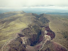
Mt. Tarawera is one of the volcanoes in the Okataina zone where eruptions have been occurring over the past 20,000 years. Tarawera's most recent eruption was in 1886 when it split along a fault creating this 8 km rift. The rift spread south of this image into lake Rotomohana causing a massive explosions, killing over 100 people and destroying the then popular tourist destination the Pink and White Terraces. An extensive description of the Okataina Volcanic Centre can be found under the Okataina heading at the NZ GNS volcanoes site.
Some idea of scale can be gained from the walking tracks along the edges of the rift (access to the mountain is by organised tour only).
Visible in the background is the cone of Mt Edgecumbe another Okataina volcano which last erupted 3200 years ago.
This image was taken from a Volcanic Air Safaris float-plane. I've had to adjust the colour levels and curves to compensate for overexposure, haze, the overcast conditions, and the tint of the windshield.
img_7378-levels-curves-usm4.jpg
No comments:
Post a Comment